FREE Express Delivery
DJI Matrice 30T Enterprise Drone
Matrice 300 RTK
DJI Matrice 30 | Enterprise Drone

SOFTWARE
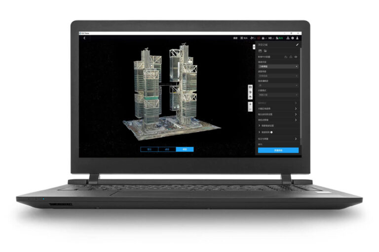
Make the World Your Digital AssetCapture, analyze and visualize your environment with DJI Terra – an easy to use mapping software developed to help industry professionals transform real-world scenarios into digital assets.
3D modelling and mapping software. DJI Terra will make handling drone data much easier, unlocking the potential of the data that drones are collecting. The photos and all the images captured from your DJI drone can now be easily transformed into digital 3D models or maps.
3D modelling and mapping software. DJI Terra will make handling drone data much easier, unlocking the potential of the data that drones are collecting. The photos and all the images captured from your DJI drone can now be easily transformed into digital 3D models or maps.
Capture, analyse and visualize your environment with DJI Terra, an easy to use mapping software developed to help industry professionals transform real-world scenarios into digital assets. Create efficient flight paths using predefined waypoint actions and adjustable parameters like altitude, speed, gimbal pitch angle, aircraft heading and more. For more complex and tight missions that require high attention to detail, use 3D Flight Visualization to design and simulate tasks on existing 3D model
This all-in-one drone mapping solution allows pilots to automate complex missions and collect real-time insights, helping surveyors plan, visualise, process, and analyse drone mapping data.
Enhance your drone operations with the DJI Ground Station Pro (DJI GS Pro), an iPad app. Conduct automated flight missions, manage flight data on the cloud, and collaborate across projects to efficiently run your drone program.
Immerse Yourself in an Authentic Flying Experience
This software tailored for the enterprise allows you to hone your piloting skills without the potential risks and costs associated with real-life training. Every aspect of DJI™ unique flight control technology is analyzed and adapted to create the most realistic simulated flying experience.
3D Models
Get sharp and realistic representations of your surroundings throughout various industrial applications, be it accident reconstruction, recreating thin power lines and complex vertical structures, managing major construction projects and more. The CUDA-based reconstruction algorithms are capable of quickly processing large amounts of data to deliver quality results.
2D Maps
Generate high resolution orthomosaics, enabling you to get detailed and accurate measurement results for all your critical projects.
LiDAR
Process point cloud data captured by the Zenmuse L1 in DJI Terra. In just one click, calculate POS data, fuse point cloud and visible light data, export point clouds in standardized formats, and generate fieldwork reports.
Multispectral9
Using multispectral data from P4 Multispectral, generate radiometrically calibrated reflectance maps for remote sensing research and more, or produce vegetation index maps including NDVI and NDRE. Create prescription maps for variable rate application using DJI’s Agras drones to improve crop yields while driving down cos
When efficiency is key, quickly render and visualize a 3D model of the mapped area. Make decisions based on the preliminary model and check for completeness immediately or plan 3D flights on-site.
Quickly generate a 2D orthomosaic of the selected area in real-time. Not only is this ideal for creating detailed flight paths in remote areas but it’s also useful for time-sensitive missions that require quick decision-making on site.
Automatically generate waypoints and flight routes based on one or more points selected in a local 3D model or point cloud (or a third-party point cloud). A simulated camera view including the selected point is displayed onscreen to enable better waypoint selection and more efficient flight route planning, automating inspection workflows.